Editor’s Note: As BLDRfly continues its series of city council explainers, starting with Alpine-Balsam last week, we’re rolling into our next segment, this time the hotly contested property for years existing as unincorporated Boulder County land: Hogan-Pancost.
“Hogan-Pancost” has become ingrained in Boulder’s environmental and City Council agenda. The 22-acre parcel sits at the epicenter of an ongoing conversation: how to best use undeveloped city land?
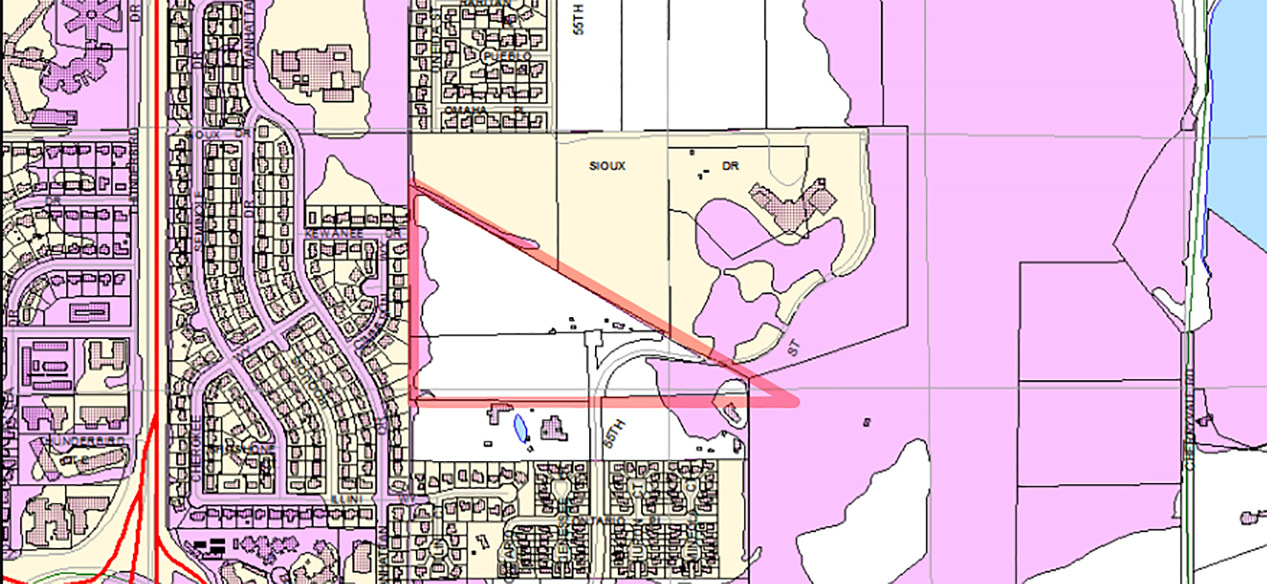
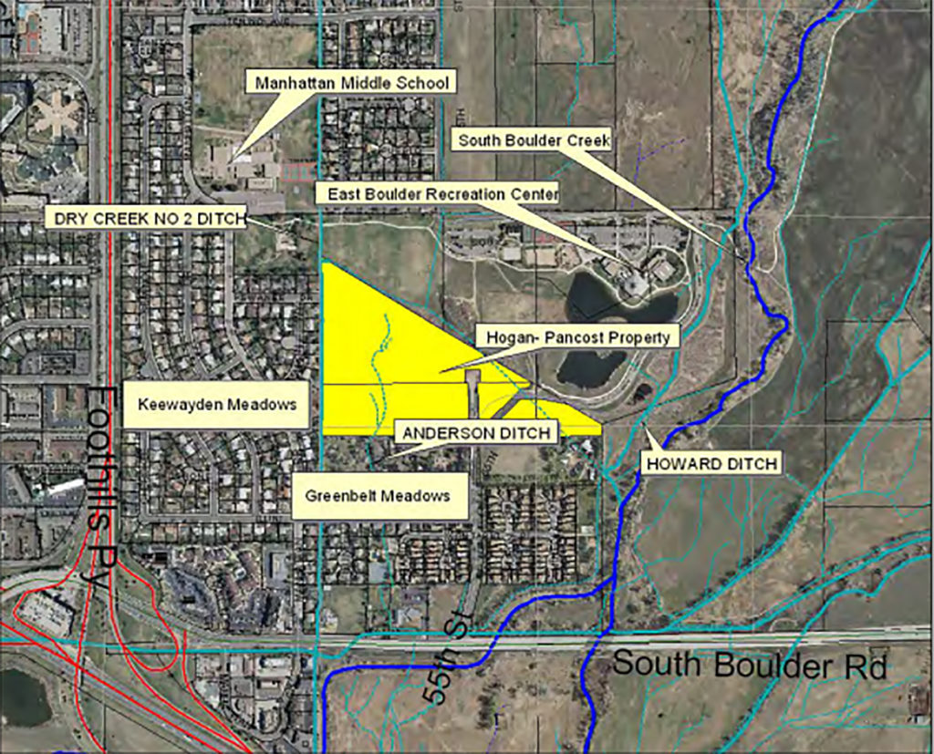
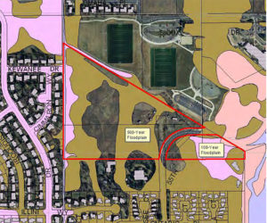
For years, Hogan-Pancost has resided within Boulder County at 5399 Kewanee Drive and 5697 South Boulder Road. It lives south of East Boulder Community Park, divided by 55th Street.
Though not officially owned by the City until 2018, the land has existed inside city growth limits since the 1970’s, previously identified as a property for urban development. Hogan-Pancost also still fell within Boulder County jurisdiction and thus, the Boulder Valley Comprehensive Plan.
Original owners by family names Hogan and Pancost eventually sold the property to Mike Boyers. Over the years, a variety of developers took stabs at annexing and urbanizing the property, always to no avail due to environmental concerns. Boyer submitted the most recent request for annexation in 2015, which came to council review in 2017, but Boyer withdrew the request that November.
Hogan-Pancost site. Image: bouldercolorado.gov
When the City finally purchased the property in April of 2018, Boulder residents thought perhaps the Hogan-Pancost zombie saga finally ended. However, since the purchase of a property does not automatically mean its annexation, the only question remains — what next?
Here’s a high-level explainer:
Municipal annexation, when a municipality expands its boundaries into areas not already incorporated into the municipality, happens frequently with developing cities expanding into neighboring areas that would benefit from a centralized municipal umbrella.
When land becomes part of a city’s jurisdictional bounds, residents enjoy certain amenities provided specifically by that city, such as water and trash pickup. All of these things that you pay for when living on unincorporated property become the responsibility of the city once annexed, including street maintenance, lighting, and snow removal as well as other health regulations and protections.
The downside to annexation — taxes increase. Residents become subject to stricter local ordinances and regulations as well as licensing requirements.
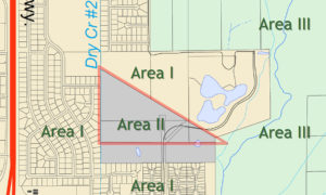
And because the Boulder County’s Low Density Residential and Environmental Protection zoning accommodates only two to six single-family homes per acre, any sort of real development requires annexation to the City of Boulder. Sharing at least one of six boundaries with the city makes a property in Area IIA eligible for annexation.
However, when the City of Boulder purchased the Hogan-Pancost land, the intent was never to be used for urban development.
The city’s ownership of land doesn’t necessitate that land’s incorporation into the city’s municipality through annexation. In fact, City of Boulder owns 46,000 acres of open spaces outside of city limits.
“City land ownership is one thing and jurisdictional boundaries are another,” explains Chris Meschuk, Boulder’s assistant city manager and interim planning director. He clarified that the prior annexation request regarding mixed-use development is no longer on the table. In fact, the City is not sure that annexation is even needed for what the applicant planned to do with the Hogan-Pancost property.
Historically, the previous owners of Hogan-Pancost property used the land for grazing and agriculture. Neighbors have always kept a far-spread but tight-knit community, and up until this summer, two leased horses roamed free on the property, taken care of by neighboring residents afraid they’d get removed if news of their free reign got out.
In February of 2018, Council approved a motion to acquire the Hogan-Pancost property. Then on April 20, 2018, Boulder purchased the land for $5 million. However, a recent decision to veto development drastically decreases the land value.
The overgrown, vacant property’s value has plummeted; estimates put its value at $182,000. Boulder has questioned the lot’s land-use since the eighties when the city first received a Hogan-Pancost development proposal in 1986.
In July, Boulder City Council met to put to rest the question of what will become of Hogan-Pancost with a decision to sign off on long-term land use, with primary goals of storm-water and flood retention and open space. The property will likely be developed to fit into the broader flood mitigation plan for South Boulder Creek, including some development at CU’s property south of U.S. 36.
Now that development is off the table, this hotly contested plot of land’s future now sits between environmental protection, flood mitigation, and potentially an urban park.
Header image: Hogan-Pancost; sourced from bouldercolorado.gov