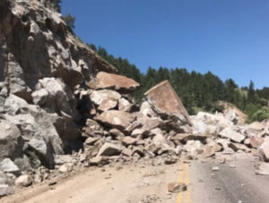
One of our team was headed up to Nederland for an afternoon hike this week and was turned back by a surprise rock fall that kept Boulder Canyon closed for an additional two hours.
This delay — among the countless others that have reconfigured Boulderites’ weekdays this spring and summer, and over the years at different locations — is the last of the major reconstructions leftover from 2013’s massive flood.
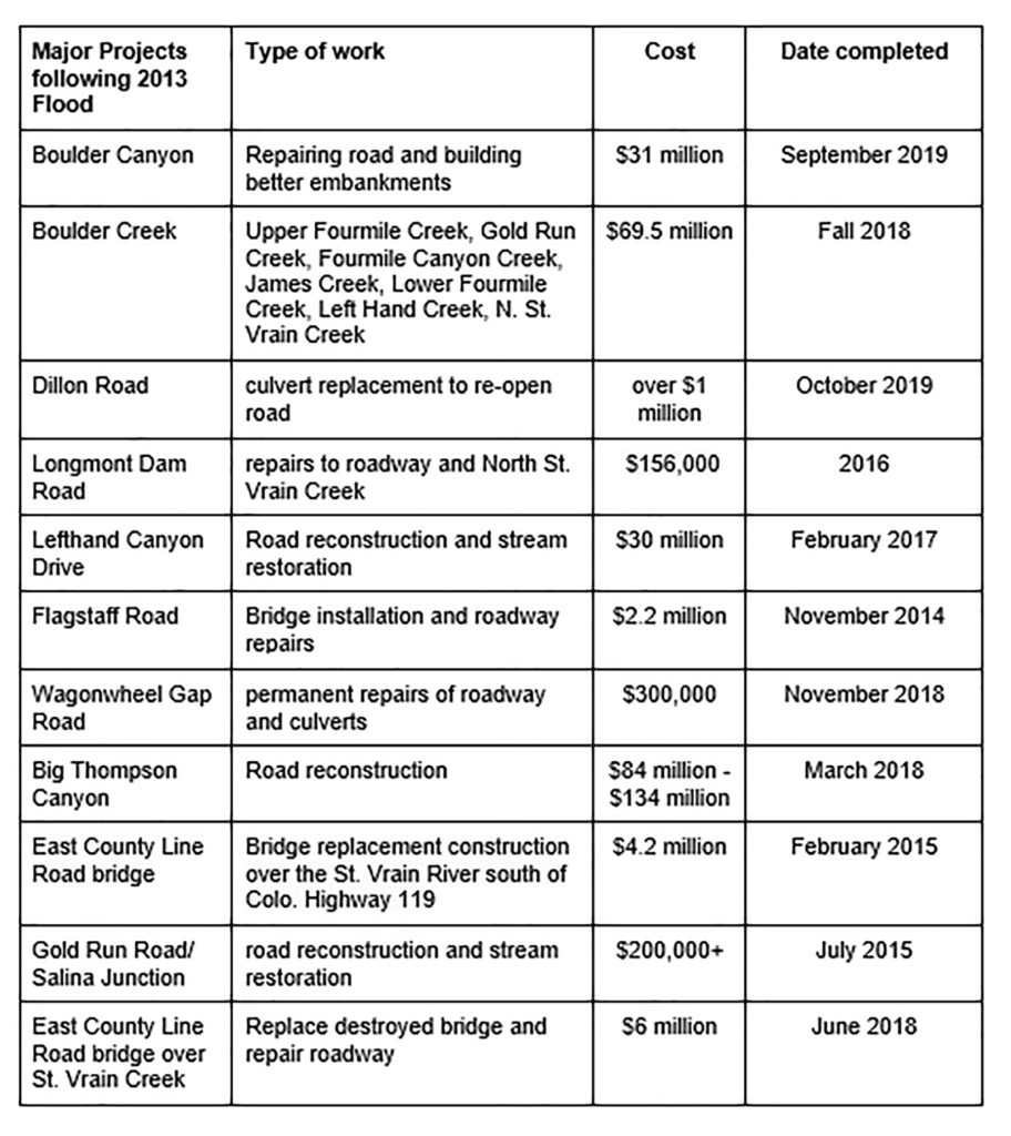
For the past six years, these special projects have included everything from resurfacing asphalt and replacing rail guards on damaged road stretches to rebuilding bridges, blasting and carving into canyons to shift roads away from river channels, building retaining walls, and creating wider shoulders.
The Boulder Canyon (Highway 119) project is the last of the barrage of projects the 2013 flood brought on, and with the canyon blasting set to end this August, that goal looks likely.
The Boulder Canyon repair forms part of a larger $31 million repair and upgrade project on a 15-mile stretch of Colorado 119 damaged by the September 2013 flood.
And finally, finally, Boulder’s on the last leg of putting the flood recovery behind us – the perfect July mountain afternoons scuttled by boulders or roadwork is soon to end. The Colorado Department of Transportation (CDOT) hopes 2021 will be the year all residual projects from the flood finally end.
It’s been a long journey.
The Highway 119 project is the last stage of major infrastructure flood recovery work.
The 1,000-Year Flood
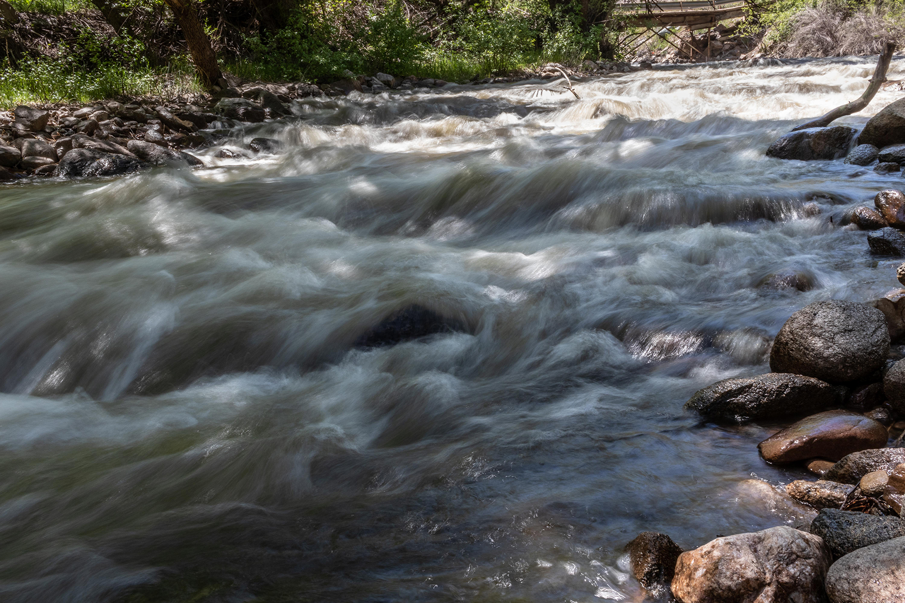
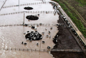
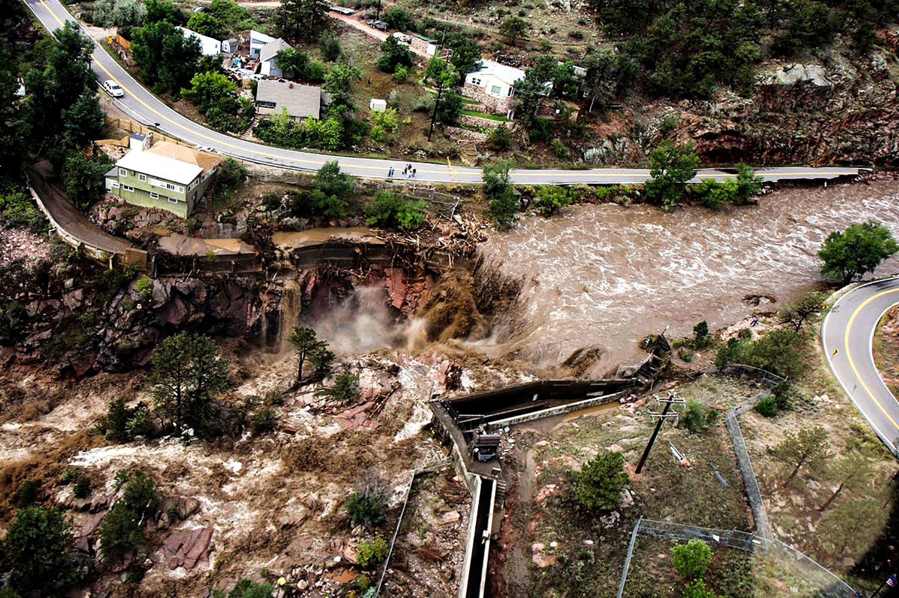
The waters that poured off the Front Range in a 1,000-year flood event in 2013 brought 16 inches of rain from September 9 to September 16 and reconfigured the Boulder landscape nearly immediately.
Boulder residents remember the catastrophic waters that devastated Colorado’s Front Range from Colorado Springs all the way north to Fort Collins that September six years ago.
The flood destroyed miles of highway and at least 30 state highway bridges — not to mention thousands of homes — with Boulder bearing the flood’s brunt.
The city estimated a total of $200 million in private property damage alone (with another staggering $28 million in damage to city infrastructure and public land) and 486 miles of roadway closures and trail closures, including Colorado 119 and Lefthand Canyon.
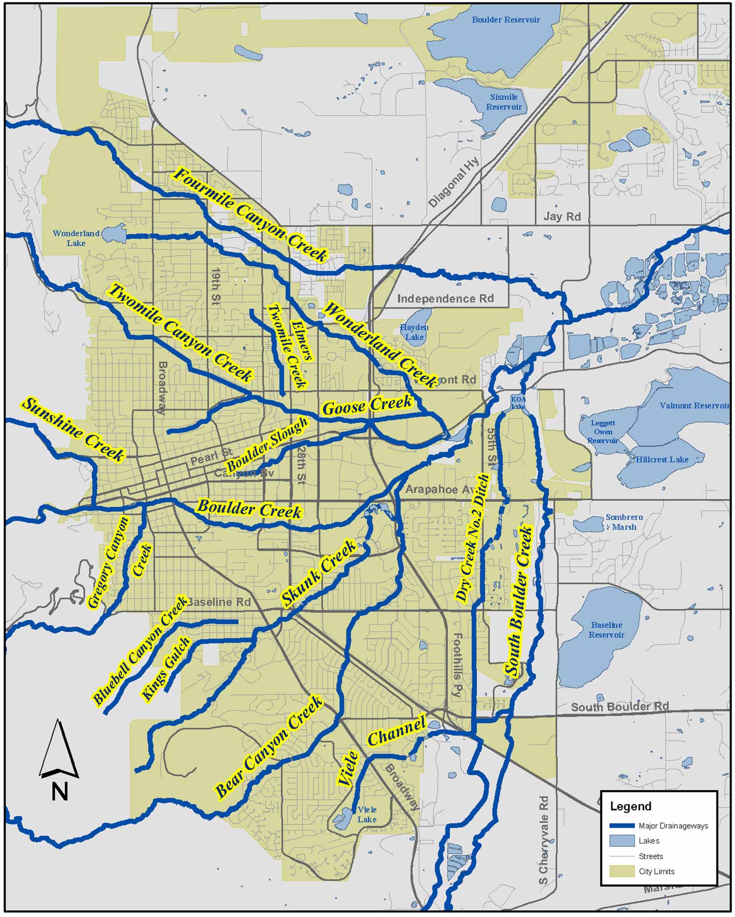
Boulder Creek and its 14 tributaries flooded significantly. Residents still remember the initial shock vividly.
Destruction
“It was crazy. On Broadway and Arapahoe, it was up to the bridge. Ten to twenty feet of water,” remembers Trevor Lindler, a Boulder local who lived on Canyon at the time.
“We got a text saying that there was a wall of water and cars coming down Canyon. We were walking in it mid-thigh just to get from our apartment anywhere at first,” says Lindler’s girlfriend, Marlie Webb.
Rushing water completely wiped out bridges, breaking through and destroying entire chunks of road and reshaping the landscape — stranding people in their homes or worse — on the other side and unable to get back.
Roads became destructive rivers as water, rocks and mud rushed down narrow mountain passages like Linden Drive in North Boulder. Mudslides crumbled driveways and flipped cars. The U.S. Air National Guard helicopter-rescued those left stranded.
Water submerged Boulder High School’s grounds, eroded road banks and carried everything from displaced refrigerators to whole houses, which scoured downstream, too.
“It was a massive landslide, an entire years-worth of water in five days,” says Chris Meschuk, one of three City of Boulder flood recovery coordinators who helped communicate response and recovery to the community. “It was the largest aerial evacuation since Katrina.”
The Betasso Water Treatment Plant up Boulder Canyon lost power and a landslide had stranded operators at the plant. City staff and volunteers bushwhacked their way up the side of the mountain to deliver supplies so that the entire City of Boulder wouldn’t lose power, Chris remembers.
Major Projects
To repair flood damage and to become more resilient in potential future events, the city of Boulder implemented the Boulder Creek Restoration Master Plan, which encompasses nearly 24-miles along the Creek and provides a planning tool for stream and ecological restoration — just one of the many plans the city of Boulder has prioritized in light of the unexpected 2013 catastrophe.
Repairs to damaged roads and spaces began immediately – launching what was to be over 120 trail repair and open space restoration projects throughout which at least 1,486 volunteers offered about 8,000 hours of their time to help rebuild and restore.
To give an idea of how involved this six-year reconstructive chapter has been, the Boulder Canyon project alone includes:
• resurfacing + replacing miles of highway
• building concrete islands to improve roundabouts
• installing new directional and safety signage
• replacing + improving storm-water drainage pipes underneath highways
• repairing + expanding shoulders
• replacing thousands of feet of guardrail
Boulder Canyon
Repair projects use explosives blasting to shift mass chunks of bedrock, then use the rocks generated from blasting to “armor” the river channels and move the road as far from the banks as possible to reduce erosion.
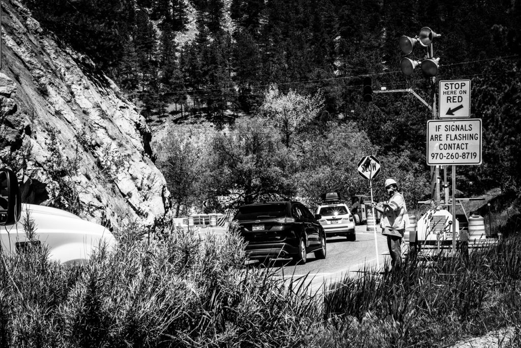
For now, blasting will continue weekdays Monday to Thursday. CDOT implemented these changes starting Monday May 20, with blasting closures between mile markers 39 and 40 from Boulder to Nederland now expanded to four days instead of previously only two.
The closure hours now span 10 a.m. to 2 p.m. Monday to Thursday.
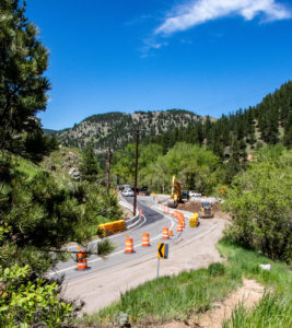
By studying Colorado’s floodplains and waterways, CDOT is shifting and replacing core infrastructure to move roads further inland to make Boulder Canyon a more sustainable, safer road.
The flood pointed out a lot of flaws in the city’s utility infrastructure and fueled a reprioritization for planning projects with a focus on sustainability.
Resilience Planning
Aside from funding damage control and roadway restructure, Boulder’s biggest flood recovery objects focus on moving forward: resilience to prepare for and respond effectively to immense community shocks like the 2013 flood.
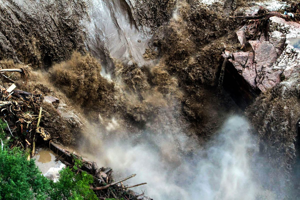
A raging waterfall destroys a bridge along Highway 34 between Estes Park and Lyons on September 13, 2013. Photo: Dennis Pierce.
Boulder’s Resilience Strategy provides a roadmap for building resilience in the city’s organization and community through strategic changes in how the city makes decisions.
The city has been awarded more than $8 million in non-FEMA grants to support recovery and resilience projects in Housing, Open Space and Mountain Parks, Utilities, and Community Services.
More than anything, Boulder wants its citizens to be prepared.
Feature image: Boulder Creek serves as the outlet of Boulder’s Front Range. Photo: Eric Forbes.