Last weekend, I took my family up to Lake Isabelle. Typical for the Brainard Lake Recreation Area, the trails were alive with hikers and fishermen.
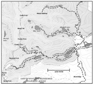
We parked the car near Brainard Lake and walked to the Long Lake Trailhead.
If you enter the park before 8 a.m. there’s a better chance of finding parking in the Long Lake Trailhead. We arrived after 11 a.m, oops!
Lake Isabelle sits 4.4 miles from the trailhead. The trail winds around ponds, dense clusters of pine and spruce trees and breaks into flat grassy valleys. Some wildflowers were still in bloom, even this late in the season.
The Indian Peaks Wilderness boundary juts up against the trail about .15 miles from the trailhead. The Wilderness Preservation System allocated 76,711 acres, in 1978 to the Indian Peak Wilderness.
Elevation climbs about a mile and a half into the hike and with breathy steps forward, the distinctive Niwot Ridge rises dramatically. The lake lies just beyond a near scramble against a calm waterfall. Isabelle Glacier’s jagged peaks loom large above the lake.
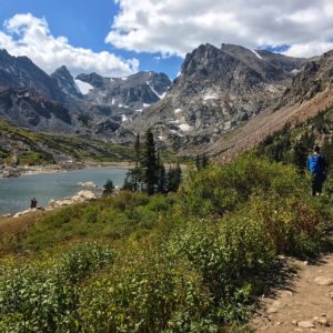
The Left Hand Ditch Company owns the water rights to Lake Isabelle and the reservoir is drained for agricultural reasons. The Lake’s water levels never reveal the drain valve.
The trail continues past Lake Isabelle for 2.1 miles to reaches Isabelle Glacier. For an even longer hike, the Pawnee Pass Trail is an out and back from the Long Lake Trailhead, measuring 9.4 miles.